We are pleased to announce new tracking map support for the iPad and other devices that are not currently supported by the Google Earth 3D Plugin.
Enjoy!!
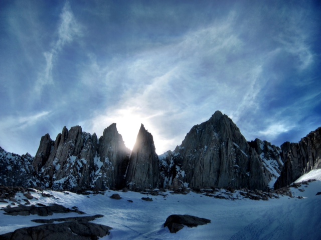
Sunday, April 24, 2011
Wednesday, April 6, 2011
After being so high, I've never been lower in all my life


This morning at 7:30 Steve and I crammed all our mountaineering into the rental car and headed over to the Lone Star Bistro for some much needed coffee. We checked out all the "I Climbed Mt. Whitney" t-shirts and took a pass. We had more extremes to reach.
Cruising southeast across the gorgeous desert scenery, we were stopped by the Highway Patrol at Father Crowley Lookout! But in a good way. The road was blocked off ahead because Dodge was making a commercial. We were directed into the scenic lookout parking lot for a 25 minute wait. Suddenly a couple of F-18's screamed low overhead that I assume was part of commercial action. Then a few minutes later two jet black Dodges (a new Charger and an SUV) ripped into the parking area follow by a blacked out Porsche Cayenne chase car complete with a roof mounted remote operated camera crane. Cool! I walked over to snap a few pictures and the CHiPs told us we get on the road because there was only a 10 minute window before they started up the commercial making again. Miles down the road we passed the opposite checkpoint and then the crew setup with big rigs, more Dodge cars and a huge lunch buffet. I wonder if there were any stars?

We continued onto Death Valley stopping for needed gas in Furnace Creek for a mere $5.48 per gallon of regular! And then to our trip's secondary objective: Badwater Basin, the lowest point in North America at -282 ft. In less than 48 hours I went from the highest point in the lower 48 states (13,508 ft.) to the lowest point in North America. Good thing I didn't implode from all that increased pressure!
From there we called Alaska Airlines in route from the car and moved up our flights to 6:45pm, drove to the Las Vegas rental car return, checked in, hung around the airport for bit and then flew home. Leslie and both boys picked me up from the airport; it was great to see the whole family!!
And just like that, the dream is realized and this adventure is over. Time to plan the next one!!
Follow your dreams to higher places,
Kurt
Sent from RainOn Adventure Tech
The gas prices will be the death (valley) of me

In Death Valley. -- $5.48 for regular!!
Sent from RainOn Adventure Tech
Tuesday, April 5, 2011
Day Four: From 12,000 to 3,700 in 180 mins.
For final day on the mountain (Tuesday), our luck with the weather held and at 9am we headed down from high camp. Since SMI runs back to back trips, there was no need to break down the tents at 12,000 so we were outta here quickly. Some plunge-stepping in soft snow got us down 2,000 ft. in about 40 mins.
Our descent got even quicker as the snow conditions and slopes below 10k were prefect for some kick-ass glissading! Four awesome runs where I set the speed record for the group.
Some more power hiking down mixed snow and dry trail found us down to the Whitney Portal trailhead in just 3 hrs all told. There we met with our guide Kurt's (great name!) 82 year-old father, John, who had donned his hiking boots and had hiked up the trail to met us and shuttle us down to the cars. I was very impressed with him. 82 years-old!! It made me think about how much I miss my own father. (God bless you Dad; thinking about you)
With pizza and beer just minutes away in Lone Pine, we threw our gear the rental car and I drove like a bat out of hell the 13 miles into town. The combined scent of 4 days of mountain on the 12 of us guaranteed not only a table but 1/2 of pizza place and speedy service to get us out of there quick!! Good times!
After lunch, the team gathered one more time in the parking lot of the Dow Villa Motel to sort out the rental the group gear, say our good byes (and pass along our well earned tips) to Kurt, Karsten, and April, our fantastic guides, and disband as a team. Bert on a redeye from Vegas to Wichita; the Charlotte folks to Vegas for one night of something that will stay in Vegas; Chuck to somewhere unknown after getting his rental car keys sprung from the trunk he locked them in; and us remaining four: me, Greg, Michele, and Steve to dinner in Lone Pine after much needed showers and naps.
The Merry-Go-Round restaurant in Lone Pine has the most unique bill-of-fare of two menus: either steaks and chops or Chinese!! I would have to say the Kung Pow Chicken was sublime. The others seemed to enjoy their steaks and baked potatoes.
That's what I call a good day!! Fun, fun, fun in the California sun.
Share the adventure,
Kurt
Sent from RainOn Adventure Tech
Monday, April 4, 2011
Summit Day
Wow! Did we score with the weather! Last two trips in a row were turned around. And we missed the wind storm that really hit high camp by one day.
Today was absolutely perfect! Not a could in the sky and no wind to speak of. The guides said it does get better than this. They woke us at 3:30am and we were climbing by headlight just before 5am. The climbing started fairly tame but they had us all roped up from the get go. Crampons, harness, helmet, and ice axe. Rope intervals were much tighter than normal glacier setups. No glaciers on Mt. Whitney. The ropes were in place to allow the guides to control any slips or falls as necessary. Thankfully it wasn't necessary today.
After reaching Iceberg Lake, the route turns up the 35 degree Mountaineers Chute. Steep cramponing until you reach "The Notch" at 14,000 ft. From there the guides put in three rope lengths of anchored fixed lines to allow for ascending the final 500 ft. of 45-50 degree slope. You do this with the use of a piece of climbing gear called an ascender, naturally!
100% of the team made the summit!
The top of Mt. Whitney is a big flat plateau that even has a structure built many years ago by the Forest Service. After lots of pictures and Facebook status updating (4 bars of AT&T 3G goodness) and a bit of lunch, we were lowered down each pitch by the guides - facing up the mountain, leaning back on the rope, and walking backwards down the 50 degree slope. Awesome! Closer to camp, we had a wicked glassade.
After another tasty dinner, we chatted for a while and headed to the tents. After breakfast tomorrow, we should hit the trail to allow us to descend all the way down to cars and drive back into Lone Pine for a team lunch.
It felt pretty good being the highest people in the US today!
Sent from RainOn Adventure Tech
Summit!!!

On the top of the lower 48 states!!! Excellent day - perfect conditions. Great crew and great guides. Feels good to be so high in California.
Kurt
Sent from RainOn Adventure Tech
Sunday, April 3, 2011
Day Two - Move to high camp

After an epic wind storm last night, we woke to a beautiful day - warm and no wind and not a cloud in the sky.
But back to the wind storm: no tents wreaked at our camp, but the wind was over 60 MPH. It was so cool that I had my headphones off in the middle of the night just to listen to the wind. I made a few audio recordings too!
A different story at high camp. In this picture George Dunn met up with us at Camp 1 on their descent after 100% summit success and is telling us about the 70-80 MPH wind that broke tent poles and shredded one their tents at high camp last night. Yozzer!
We had another great day hiking today in nearly prefect conditions that look to be holding for our summit bid tomorrow starting around 3am. I'm feeling GREAT and super excited about tomorrow's serious climbing. Thanks Tootz and Monika, Alaina and Carl for getting me ready on all fronts.
To the top of the lower 48!!!
Kurt
Sent from RainOn Adventure Tech
Saturday, April 2, 2011
Day One - TH to Lower Boy Scout Lake

Today was cool!! After hitting the road up Whitney Portal, we parked the cars where the road was closed for the season and shuttled packs and people up to nearly Whitney Portal (8,365 ft.). The lead guide, Kurt (great name with the correct spelling), has a beater Toyota truck for that exact purpose.
We hiked nearly all day on alternating snow and trail at first and then all snow upto 9,900 ft. before donning our snowshoes. Lower Boy Scout Lake is at 10,300 ft. and the site of Camp 1. Kurt set a super mellow pace with lots of breaks. I had no complains!
The crew is a really nice group of folks but offer no threat of encroachment to the Boys of Aconcagua bond. They hail from Seattle (yes, another Microsoftie, well former), Pittsburgh, Charlotte, Wichita, Baltimore and Orlando. The two other guides are April and Karsten.
Pretty warn day with some clouds has now turned to windy and a little bit of snow, which nicely waited until we were tucked into out tents.
Tomorrow we move to our high camp, just below Iceberg Lake. Sounds cold. Hoping the wind dies down. Nothing like trying to set a tent at 12,300 ft. in high wind.
I'm already starting to feel high here in California,
Kurt
Sent from RainOn Adventure Tech
Gear Check

Lots of stuff! That's my stuff in the foreground. Note the extra large pee bottle (marked with RED (do not drink) duct tape).
Sent from RainOn Adventure Tech
Team Breakfast

All of the climbers are present and waiting for the guides to show up any second. Breakfast at the Mt. Whitney Restaurant.
After breakfast, distribution of group gear and personal gear checks, we will head up the mountain around 11am.
Sent from RainOn Adventure Tech
Friday, April 1, 2011
Whoa!
...HIGH WIND WATCH IN EFFECT FROM SATURDAY AFTERNOON THROUGH LATE SATURDAY NIGHT... THE NATIONAL WEATHER SERVICE IN LAS VEGAS HAS ISSUED A HIGH WIND WATCH FOR THE EASTERN SIERRA SLOPES AND THE OWENS VALLEY...WHICH IS IN EFFECT FROM SATURDAY AFTERNOON THROUGH LATE SATURDAY NIGHT. * WINDS: WEST WIND GUSTS OF 70 MPH OR HIGHER ARE POSSIBLE ON THE EASTERN SIERRA SLOPES...AND GUSTS OF 60 MPH OR HIGHER ARE POSSIBLE IN THE OWENS VALLEY. * TIMING: THE STRONGEST WINDS ARE EXPECTED TO BEGIN ON THE EASTERN SIERRA SLOPES SATURDAY AFTERNOON...AND POSSIBLY SPREAD INTO THE OWENS VALLEY SATURDAY EVENING OR SATURDAY NIGHT. * LOCATIONS: ASPENDELL...INDEPENDENCE...BISHOP...LONE PINE...HIGHWAY 395. * IMPACTS: STRONG CROSSWINDS COULD MAKE TRAVEL VERY DIFFICULT ON HIGHWAY 395. BLOWING DUST COULD REDUCE VISIBILITY TO LESS THAN A QUARTER MILE NEAR DRY LAKE BEDS. PRECAUTIONARY/PREPAREDNESS ACTIONS... A HIGH WIND WATCH MEANS THERE IS THE POTENTIAL FOR A HAZARDOUS HIGH WIND EVENT. SUSTAINED WINDS OF AT LEAST 40 MPH AND...OR GUSTS OF 58 MPH OR STRONGER MAY OCCUR IN THE WATCH AREA. CONTINUE TO MONITOR FORECASTS FOR THE LATEST INFORMATION.
Sent from RainOn Adventure Tech
Touchdown in Vegas
Right on time. Rental car and 4 hour drive to Lone Pine, CA next.
Sent from RainOn Adventure Tech
Security Clearance

At the gate, ready to fly. Made it through bag check and security. But not before carefully juggling 4.8 pounds out of my duffle into my carry on to get under 50 lbs. You really have to think about what those items are. Ice ax? Not really a good choice.
Sent from RainOn Adventure Tech
Heading to the airport!
Flight on time to Las Vegas at 9:55am. Thanks for the lift Stuart!
Sent from my phone
Thursday, March 31, 2011
T-1 Day: Packing completed
The packing is done. The checklist has been checked. Headed to the airport at 8:00am for my flight to Las Vegas. Then a bit of a drive across Death Valley to Lone Pine, CA for the night. Saturday, we head over Whitney Portal and up the mountian!
Tuesday, March 29, 2011
Hmm... Interesting but with GOOD news!
From: George Dunn
Sent: Tuesday, March 29, 2011 12:24 PM
To: Kurt Hunter; etc.
Subject: RE: IMG Mt. Whitney Climb, 4/2-5, 2011
Dear Whitney team,
Just a quick update on the first two climbs the past weekend. My climb got up to a “low” high camp on our second day with lots of slow going due to new snow on the route and strenuous trail breaking.
Unfortunately we woke up to stormy, snowing conditions on our summit morning which didn’t allow a summit attempt. We descended that same day in stormy conditions which improved as we got lower. On the final day remaining a couple of the team members opted to go rock climbing for the day which was great fun.
The second climb had similar bad results, they had very high winds at their first camp which helped to increase the avalanche danger on the upper mountain. The team made a group decision to turn back on day two in the face of very strong evidence that there would be avalanche hazard higher on the mountain. The second team did a fun rock climbing day yesterday. I joined them and their guide team for a great outing. Most of the team went out today for a class on avalanche hazard evaluation and avalanche transceiver training.
The good news is the weather is back to normal again with clear sunny skies predicted for the next couple days and decent conditions for further down the road. The next few days of weather should consolidate the snowpack and will help to reduce or eliminate avalanche conditions on the mountain. I am pretty sure this is the first time we have ever missed two Whitney summits in a row and I feel confident the conditions will be settled and back in good shape by the next climb.
I head back up the mountain on Thursday and look forward to meeting you on your second day on the mountain as my team descends from high camp. I trust I’ll have better news to report about summiting when we meet.
Don’t forget to meet your guides at 7:00 a.m. at the Mt. Whitney restaurant across the street from the Mt. Whitney Hostel in Lone Pine on April 2.
All best,
George
George Dunn
International Mountain Guides
Monday, March 28, 2011
RainOn Adventure Tech Field Kit

- iPhone 4 for AT&T 32GB
- mophie juice pack plus for iPhone 4 AT&T
- Power Support HD Anti-Glare Film Set
- zoomMediaPlus zoomIt SD card adapter for importing Digital Still Camera photos and GPS tracklogs
- Klipsch Image X10i In-Ear Headphones
- Comply T-100 Foam Tips for headphones
- mophie USB charging cable
- a broad set of indispensable iOS apps for communications, media entry and editing, and other services
- SPOT Connect satellite communicator w/ 2 Energizer L91BP Lithium AA Batteries
- Energizer L91BP-8 Lithium AA Batteries (1 - 8-Pack = for SPOT Connect)
- Canon PowerShot S90 10.0 megapixel digital still camera
- SanDisk Ultra SDHC 16 GB memory card
- Canon NB-6L battery pack (+ 2 spares)
- Timex Expedition WS4 watch
- Orange Pelican 1400 Case
We are very excited to be using the mophie juice pack plus for the iPhone 4 to more than double the battery life of the iPhone in such a stylish and cool case. Also the mophie's standard micro USB connector for charging means one less cable for us to carry. The same cable is also used to charge the zoomIt SD card adaptor and the standard Apple iPod cable is not needed in the field. In our opinion, mophie makes the best battery cases for iOS devices and we can't wait to check the performance on the top of The Lower 48 States.
Saturday, March 26, 2011

Check out IMG's Whitney posts on their blog
IMG Blog - Whitney related posts
Getting really excited about my turn starting one week from today!!
Getting really excited about my turn starting one week from today!!
Friday, March 18, 2011
T-Minus Two Weeks
Getting really close now. Discussed increasing carbo intake starting three days before departure to build up some fuel reserves. Completed a long snowshoeing training hike last Sunday up Hex Mountain. Feeling good! Now I need to get all the electronics/blog/tracking/etc. all in shape and start getting my gear sorted.
Wednesday, March 2, 2011
T-Minus One Month!
Wow! Where did all the training time go? In just 31 days, I'll be climbin' again. Nice. I can't wait to stand on the highest point in the lower 48 states and the roof top of California. That's what I call getting high!
Saturday, January 15, 2011
Saturday, November 13, 2010
Trip Itinerary
APR 01: Fly from Seattle to Las Vegas, car poll with other climbers or rent a sweet ride (perhaps the Cadilac of mini-vans?), drive to Long Pine, CA and bunk for the night at Dow Villa Hotel.
APR 02: Meet at the Mt. Whitney Cafe in Lone Pine for breakfast at 7:00 a.m. Drive to the end of the Whitney Portal road around 11:00 a.m. as a team after issue of group gear and individual gear checks. The road is not plowed to Whitney Portal in the spring and there is usually a mile or more to hike to the road's end. In normal conditions, we will leave cars at a parking area near the road closure sign and then shuttle the group as far as we can get. We will likely use snowshoes from the start. The way from Whitney Portal (8,400') will be all snow, with some steep snowshoeing terrain through pines and around exposed granite slabs. The day will be a long one, 6 or more hours, with a heavy pack. Our evening camp will be in the vicinity of Lower Boy Scout Lake, at about 10,300' in elevation.
APR 03: We will move up to a high camp somewhere below Iceberg Lake (12,240'), another very full day. It may be cold at high camp, in the range of +20°F to as low as 0°F overnight.
APR 04: Summit day. The Mountaineer's Route ascends a large, snow filled gully up to a notch just north of the summit. The gully may be firm snow or knee deep step kicking, depending on conditions. It is 30-40° in angle. From the notch, a short, steeper gully will be belayed or anchored with several fixed ropes to facilitate our ascent to the summit. The guides will lower the team from anchor point to anchor point back down to the notch. We will descend the route to our high camp.
APR 05: Pack up and return to the road head. End of trip. We will hope to be back at our vehicles by mid-afternoon, noon to 2 p.m. depending on conditions. We normally meet for lunch as a team down in Lone Pine to celebrate our success. Overnight again at the Dow Villa Hotel in Lone Pine.
APR 06: Drive to Vegas, baby! Hop a plane back to Seattle.
The Latest Adventure Plan
I've signed up with International Mountain Guides to climb Mt. Whitney via the Mountaineer's Route.
Mt. Whitney is the highest point in the continental U.S. Standing 14,505 ft. it is only 94 feet higher than Mt. Rainier. The Mountaineer's Route is a scramble in the summer, but a snow climb in the winter and spring with some slopes up to 45 degrees.
You might be wondering why I would use a guide service for a domestic climb on a such a popular mountain. Two reasons: 1) logistics/reliability of scheduling - last year I tried to put together a group of folks to climb Whitney and failed due to people unable to commit and dropping out and the difficulty and luck involved in getting a permit, and 2) the route - the Mountaineers Route in early spring offers climb more like Rainier than the typically crowded Whitney Trial hiking trial. Using a guide service gives a fixed date and allows me to explore a more advanced route.
I've opted for the Apr 2-5, 2011 trip led by Kurt Wedberg of Sierra Mountaineering International and there will be 9 climbers and 3 guides.
Subscribe to:
Posts (Atom)